Finding Your Way: The Ultimate Guide to Navigating a Yukon Map for Your Next Adventure
There is something deeply stirring about the vast, untamed wilderness of North West Canada. When you look at a Yukon map, you aren’t just looking at lines and labels; you are looking at a blueprint for one of the world’s last great frontiers. Whether you are planning a high-octane expedition or a peaceful retreat to witness the northern lights, understanding the layout of this territory is your first step toward a safe and memorable journey.
The Yukon is a place where the scale of nature can feel overwhelming. Spanning over 480,000 square kilometres, it is larger than many European countries combined. However, with the right tools and a bit of preparation, navigating this wilderness travel destination becomes an empowering experience. In this guide, we will explore how to master the Yukon map, identify key regions, and ensure your adventure planning is as robust as the terrain itself.
Why a Detailed Yukon Map is Your Most Essential Travel Tool
In our modern era of digital convenience, it is easy to rely solely on smartphone GPS. However, in the remote stretches of the Yukon, cellular service is often non-existent. A physical Yukon map or a pre-downloaded topographic version is not just a convenience—it is a critical safety item. Understanding the remote travel realities of the north means recognising that help may be hours, or even days, away.
According to Britannica, the Yukon’s geography is dominated by rugged mountains and the mighty Yukon River. Without a proper map, it is easy to lose track of distances between fuel stations or campsites. Using a reliable mapping service like Google Maps for initial planning is great, but cross-referencing with official Yukon Road Reports is vital for real-time conditions.
Safety First: Navigating the Elements
The weather in the Yukon can be unpredictable. When studying your Yukon map, pay close attention to elevation levels. Higher altitudes can harbour snow even in the summer months. To stay safe, ensure you have reviewed winter safety protocols if travelling outside the peak summer window. Health organisations like the Mayo Clinic on Hypothermia emphasize the importance of staying dry and warm in sub-arctic climates.
Key Regions to Identify on Your Yukon Map
To truly understand the territory, you must break down the Yukon map into its primary regions. Each area offers a unique blend of Klondike history and natural wonder.
- Whitehorse: The “Wilderness City” and the territory’s capital. Most journeys begin here. Refer to a Whitehorse guide to navigate its urban trails and amenities.
- Dawson City: The heart of the 1898 Gold Rush. This town is a living museum, recently recognised as a UNESCO World Heritage site.
- Kluane National Park: Home to Mount Logan, Canada’s highest peak. This is a premier spot for hiking trails and mountaineering.
- The Silver Trail: A quieter route leading to Mayo and Keno City, perfect for those seeking solitude.
When planning your route, consider the distances. The Alaska Highway is the main artery, but secondary roads like the Dempster Highway take you across the Arctic Circle—a feat that requires significant preparation and high-quality outdoor gear.
Comparing Yukon Travel Regions
Use the following table to help decide which area of the Yukon map to prioritise for your interests:
| Region | Primary Attraction | Best For | Accessibility |
|---|---|---|---|
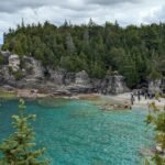
| Southern Lakes | Emerald Lake | Photography & Canoeing | Easy (Near Whitehorse) |
| Klondike | Gold Fields | History Buffs | Moderate (Paved Highway) |
| Kluane | Glaciers & Peaks | Advanced Hiking | Moderate (Haines Junction) |
| North Yukon | Tombstone Park | Rugged Backcountry | Challenging (Gravel Roads) |
Essential LSI Keywords for Savvy Navigators
When researching your trip, you might encounter specific terms that are common in northern geography. Integrating these into your search will yield better results. Familiarise yourself with the topography of the region, the location of the Northwest Territories border to the east, and British Columbia to the south. Keep an eye out for Tombstone Territorial Park, often called the “Patagonia of the North,” and understand the vital indigenous heritage of the 14 First Nations who call this land home.
For those interested in wildlife tours, your Yukon map should highlight river corridors where grizzlies and caribou are frequently spotted. Organisations like Nature.com often publish studies on the unique ecosystems found within these Canadian territories.
Top Tips for Using Your Yukon Map Effectively
Mapping out a road trip through the Yukon requires more than just knowing where you are; it’s about knowing what you need. Follow these expert tips:
- Check for Road Closures: Use MapQuest or local government sites to check for seasonal closures, especially on the Dempster Highway.
- Mark Fuel Stops: In some areas, fuel stations can be 200 kilometres apart. Mark these clearly on your Yukon map.
- Consult Parks Canada: For those visiting Kluane National Park, always check in at a visitor centre for the most accurate trail maps.
- Understand the Scale: Distances in the north are deceptive. What looks like a short drive on a map can take hours due to gravel surfaces.
- Respect Indigenous Lands: Much of the Yukon is traditional territory. Use your map to identify and respect private settlement lands.
Preparation is key to enjoying the photography spots scattered across the territory. If you are venturing onto the water, a specific Yukon River guide is indispensable for spotting safe camping tips and eddies. The NASA Earth Observatory provides incredible satellite imagery that shows the sheer power and scale of this waterway.
Health and Wellness on the Road
Long drives and remote hiking can take a toll on the body. Ensure your Canadian territories journey is supported by good health practices. Consult the NHS Travel Vaccinations guide if you are an international traveller. Furthermore, the Canadian Red Cross offers excellent resources for wilderness survival and first aid that every Yukon explorer should review before setting out.
Harnessing Digital Tools for Modern Exploration
While we advocate for paper maps, digital tools from Travel Yukon and historical insights from the Smithsonian Magazine can enrich your understanding of the landscape. High-resolution imagery from National Geographic can help you visualise the terrain before you arrive, making your interaction with a physical Yukon map much more intuitive.
Remember that the Northern Lights are best viewed away from the light pollution of Whitehorse. Use your map to find elevated, north-facing clearings. Always check the weather via Environment Canada to ensure clear skies for your viewing. If you are planning canoeing adventures, ensure your GPS device is loaded with offline maps to complement your physical Yukon map.
Frequently Asked Questions (FAQs)
Where can I get a high-quality physical Yukon map?
Physical maps can be purchased at most visitor information centres in Whitehorse or Dawson City. You can also order official topographic maps from the Government of Canada’s natural resources department before your trip begins.
Is the Dempster Highway marked on a standard Yukon map?
Yes, the Dempster Highway is a major feature on any Yukon map. It is the only public highway in Canada that crosses the Arctic Circle. However, it is a gravel road, so ensure your map includes information on service stations and emergency stops along the route.
Are the hiking trails in Kluane National Park easy to follow?
While many trails are well-marked, the backcountry of Kluane can be quite challenging. It is highly recommended to carry a detailed topographic Yukon map and a compass, as well as a GPS satellite messenger for emergencies.
Can I rely on my phone for navigation in the Yukon?
In short: No. While phones are useful in Whitehorse and Dawson City, you will likely lose signal as soon as you leave the city limits. Always carry a paper Yukon map and download offline maps for use in areas without service.
What is the best time of year to use a Yukon map for a road trip?
The best time for a road trip is between June and August when the days are long and the roads are mostly clear of snow. If you are travelling in the shoulder seasons (May or September), be sure your map highlights which secondary roads may still be closed.